Murmurations over G2/Manor Field
The real impact on Walberswick…
data from our surveys
National Grid/LionLink have been trying to create the impression that their proposed landfall site at Manor Field (G2) is ”south” of the village in an open and scarcely used field… THIS IS FALSE. It is in the heart of the village and surrounded by houses on three sides with a dense network of local and long-distance footpaths including the new King Charles III Coastal Pathway. A staggering 48,821 people have used these lanes since May 24th 2024. Find out more
Wildlife
69 breeding bird species were recorded, and an additional 54 species, including rare Cetti’s warblers, bearded tits and woodlarks, nest along the proposed cable route and adjacent to the landfall site, whilst bitterns and marsh harriers routinely use the same areas for foraging.
20 volunteers have surveyed 300 sites over 6 months for reptiles, finding important populations of adder, lizard, slowworm and grass snake around the proposed landfall site and cable route corridor.
Using state-of-the-art static bat detectors, a team of 6 surveyors have sampled over 400 detector nights across 26 locations. 9 of the 17 UK bat species have been recorded to date, and we will continue targeted monitoring in 2025. 2 important bat roosts have been discovered. Find out more
A huge thanks to our loyal team of volunteers and for all your donations which have enabled us to buy the specialist kit and get the legal advice to make all this happen.
Latest news

People Survey
Updates from the People Counter survey conducted on and around proposed landfall sites.

Wildlife Survey
Updates from the Wild Survey conducted on and around proposed landfall sites.

Legislation/policy - why our surveys matter
What do our wildlife survey and the proximity to protected sites actually mean in relation to LionLink and their requirement to comply with environmental regulation?

Works have now started… but with restrictions
LionLink assumed that their application to begin digging trenches and boreholes around Manor Field and Track Field, on the beach and various access points would just be nodded through.

Object to LionLink survey planning application
National Grid/Lion Link need permission from our council to carry out test drillings for their devastating plans in Walberswick. We can all object and comment

Help with the Scoping document
National Grid are putting us under huge time pressure to respond to their scoping document. We need your help!

Big Walberswick Wildlife Watch
Please join the Big Walberswick Wildlife Watch and help us record the wildlife on Walberswick’s proposed landfall sites.

Art for WALL Fundraising Project
Local artists have created and donated a piece of art connected with Walberswick, a special place to them all, to help protect this precious habitat.

What Happens Next?
We had an amazing response to our call for everyone to send emails and letters to National Grid Ventures, MP’s, Councillors and others as part of the non-statutory consultation process.

Walberswick in the press
‘It’s like buying an iPhone and not having a cable’: UK’s bid for net zero in the balance due to grid ‘blind spot’
Help us raise funds
Running the WALL campaign costs money!
If you are worried about the threat that LionLink poses to Walberswick and are able to help by making a contribution to WALL please donate here
Our mission
WALL wholeheartedly supports the UK’s commitment to achieve Net Zero by 2050 and recognises the importance of renewable energy to achieving that goal.
However, WALL believes that National Grid’s proposal to land their LionLink interconnector cable on the Suffolk coast is driven primarily by reducing costs and boosting their profits.
It will result in irreparable damage to the beautiful natural environment surrounding Walberswick, reduce biodiversity and harm local businesses and the economy.
WALL opposes LionLink and believes that the best solution is for National Grid to create an offshore grid and bring cables ashore at an existing brownfield site closer to London and the South East, where demand for electricity is highest.
FAQs
What does Lion Link want to do?
LionLink proposes to bring ashore cables interconnecting the UK to Holland at one of two greenfield sites in Walberswick. These sites are at the beach hut car park or at Manor Field in the centre of the village. The huge earthworks to bury the cables will impact upon the beach, the dunes, the river, the marshes and the various protected lands that surround Walberswick.
How long will it take?
National Grid Ventures say the LionLink project could take 8 years to complete, beginning with the initial consultation in 2022 through to the interconnector cable coming into service in 2030. National Grid will probably decide on their preferred landfall site in 2024, start a statutory consultation in 2025, aim to get planning approval in 2026 and start construction in 2027. The process of constructing the landfall site (either G or G2) and then laying the cable to the proposed substation near Friston could take up to 4 years.
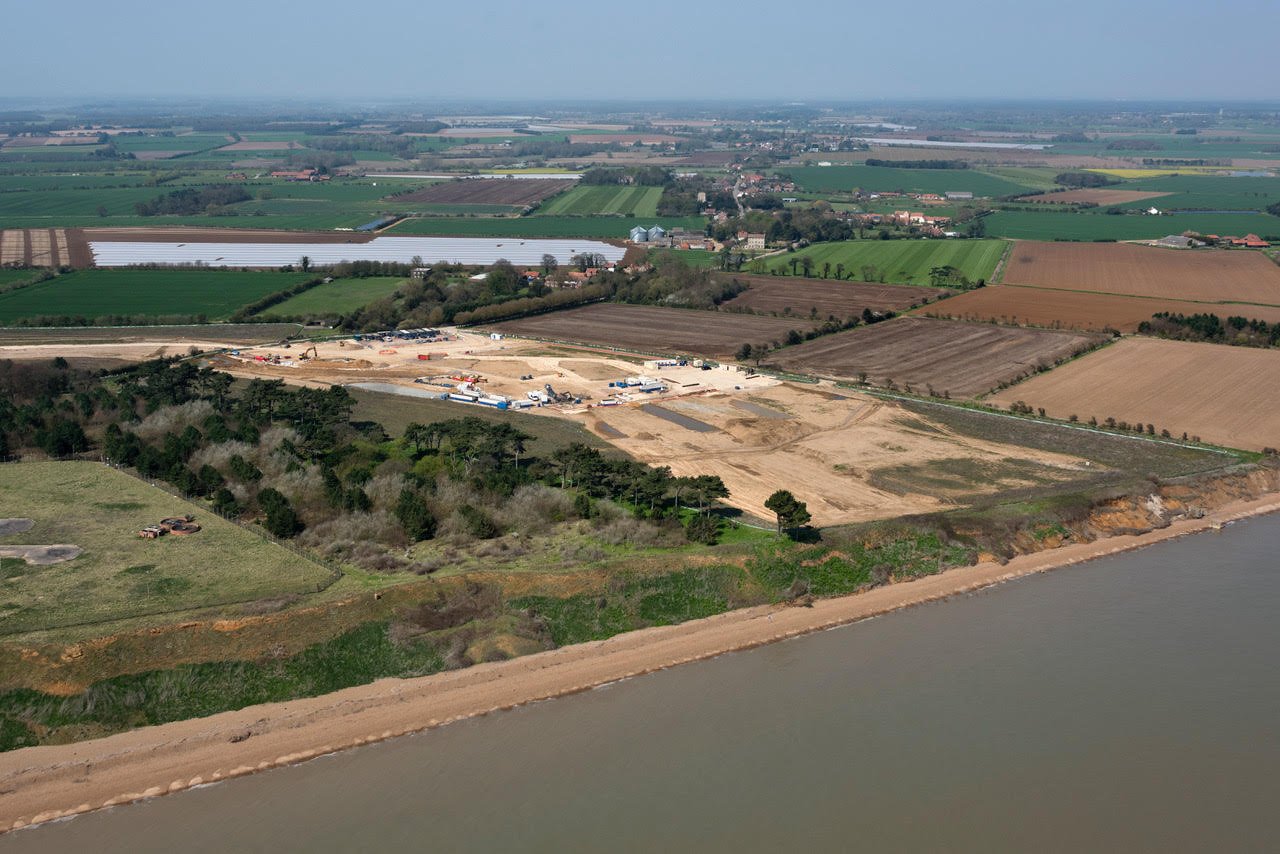
What does it look like?
This aerial photograph shows the same landfall process happening at Bawdsey 30 miles away. The image hasn’t been doctored… the cable route is as wide as a motorway.
What’s the alternative?
An offshore grid through the North Sea connected to brownfield sites closer to where the power is needed would create a sustainable, non-invasive solution that can be added to. Our North Sea neighbours in Belgium, Germany, Holland and Denmark are rolling these out… why can’t we?
Who is LionLink?
LionLink is a private company posing as a public one. They are accountable only to their shareholders so are not making decisions that are focused on the public good or the costs they impose on our communities.
Who is WALL?
Walberswick Against LionLink is a local campaigning organisation formed by a group of Walberswick residents opposed to National Grid’s LionLink proposal. It started as a WhatsApp group which grew to have over 230 members. WALL is run by volunteers who are organised through a Steering Group with sub-groups working on Communications, Fund-raising, Environment, Legal, Energy Strategy and other topics.